In 2013, the ArcGIS for Local Government solution is focused on ArcGIS Online and expanding the maps and apps in the solution offering. We want to make it easier for you to deploy ArcGIS Online in your organization and we’re developing a series of ArcGIS Online web application templates so you can continue to expand the value of GIS in your organization. The application templates are available natively in ArcGIS Online and the first application, called the Parcel Viewer, is available now with the March 2013 release of ArcGIS Online.

The Parcel Viewer application is an HTML5/Javascript application that can be used on desktops, tablets and smartphones “out of the box” (or “out of the cloud”…). This application was designed to support simple public access applications but as you’ll see, it can be configured very easily to support a diverse set of mapping needs in your organization.
Let’s take a look at how you can quickly configure the Parcel Viewer in three easy steps.
Step 1: Author your webmap
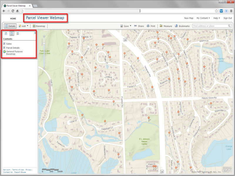
In this example, I am going to configure a land records application that can be used by the general public to review property information and property sales in a neighborhood. I’ve added the appropriate operational layers to my webmap and defined the information popup users will see when they click on a parcel or property sale in the map. The Parcel Viewer webmap I have authored has a basemap (tiled map service) and two feature services, one for the Sales and a second for the Parcel Details. All of these services are hosted in my ArcGIS Online Organization.
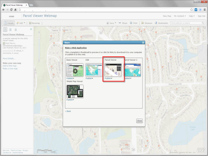
Step 2: Share your Parcel Viewer application
After you’ve completed your webmap, click “Share” and select “Make a Web Application”. Then select the new Parcel Viewer application available now in the ArcGIS Online gallery. You can publish the application immediately or preview it before you publish it.
Step 3: Configure your Parcel Viewer application
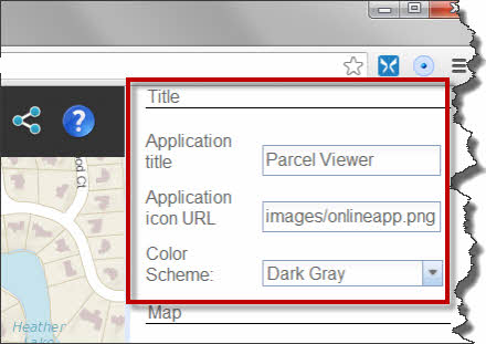
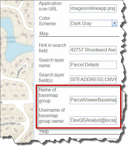
After you’ve shared your Parcel Viewer application, you can quickly configure it to leverage the webmap you authored. When you select “Configure App” on the ArcGIS.com item page, you can change the following characteristics of the application to meet your needs:
1. The name of your application, the application icon, and the application’s color scheme.
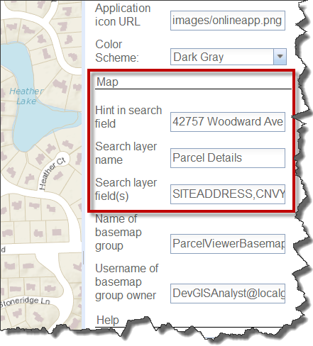
2. The name of the layer in the webmap you’d like to search against and the fields in that layer you like to search (ex. OwnerName, ParcelID, Address).
3. The basemap collection you’d like to use in the application. You can create an ArcGIS Online group that includes the basemaps users can interact with in the application and then use that group in your configuration.
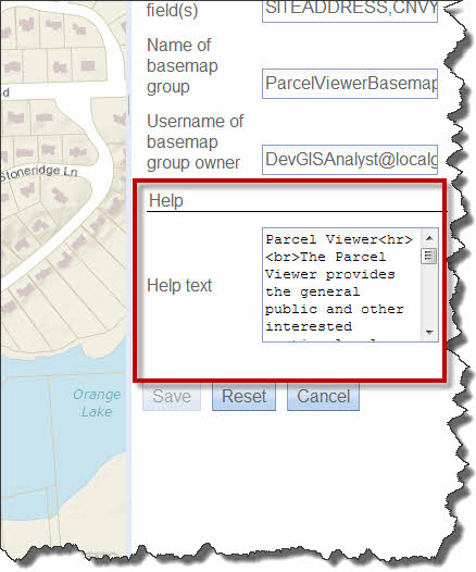
4. Any help text you’d like to share with users of the application. This may also be a place where you incorporate disclaimers or any usage requirements you typically provide in your web applications.
Once you’ve finished configuring your application, click “Save” and you’re done. You’ve finished authoring a Parcel Public Access application for your organization.
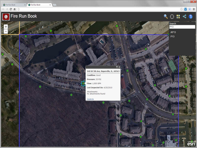
While the Parcel Viewer was designed to support simple public access applications, it can also be configured quickly to support other workflows in your organization. With the right webmap, the Parcel Viewer can be configured to…..
Provide an online Fire Run Book that allows firefighters to search for a map grid and review hydrant information.
Or, provide assessors in your community with a simple application that provides an overview of property value information for each assessment neighborhood.

That is just a few examples of how you can use the Parcel Viewer application to bring content you author in a webmap to life and deliver focused applications to knowledge workers in your organization and citizens we serve.
This is just the beginning for the local government solution offering in the cloud. As we incrementally roll out new ArcGIS Online applications, you’ll be able to leverage the cloud solution to configure new maps and apps that were previously only available on your local computing infrastructure. Over time, we’ll continue to add web application templates to ArcGIS Online. These application templates will complement the applications we already provide in the solution.
We look forward to your feedback and seeing how you leverage the Parcel Viewer application in your organization.